
Application Description
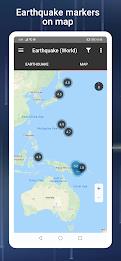
The PH Weather and Earthquakes app is your ultimate resource for real-time weather and seismic information in the Philippines. Powered by data from PAGASA's Project NOAH and PHIVOLCS, it delivers up-to-the-minute forecasts, earthquake alerts, tsunami warnings, and volcanic activity updates. But the app's functionality extends beyond the Philippines; it also includes a global earthquake list sourced from the U.S.G.S.
This comprehensive app offers a suite of monitoring tools including Doppler radar, various sensor readings (stream gauge, rain gauge, tide level, weather station), and detailed hazard maps for floods, landslides, and storm surges. It also provides essential emergency tools – a flashlight, strobe light, siren, and compass – ensuring you're prepared for any eventuality. Additional features include satellite imagery, dengue fever reports, government Twitter feeds, a critical facilities directory, and a moon phase calendar.
For a complete weather and disaster preparedness solution, this app delivers:
- Precise Weather Data: Access 4-hour and 4-day weather forecasts, cyclone tracking, and typhoon/hurricane updates from PAGASA's Project NOAH.
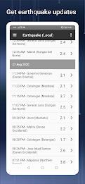
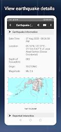
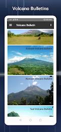
- Natural Disaster Alerts: Receive immediate notifications on earthquakes, tsunamis, and volcanic activity from PHIVOLCS.
- Advanced Monitoring: Utilize Doppler radar, sensor data, and interactive hazard maps to stay informed and safe.
- Emergency Toolkit: Always have a flashlight, strobe, siren, and compass readily available.
- Bonus Features: Explore satellite imagery, dengue reports, government updates, critical facilities information, and a moon phase calendar.
Suggest improvements or features via their official Facebook page. Download the PH Weather and Earthquakes app today for comprehensive weather and disaster preparedness.
PH Weather And Earthquakes Screenshots
Reviews
Post Comments
Trending Games
Trending apps


Topics
More
Top-Rated Productivity Tools to Boost Your Workflow
Mind-Bending Puzzle Games for Android
Best Productivity Apps to Boost Your Efficiency
Offline Puzzle Games to Play Anytime
Explore the World of Arcade Games
Best Casino Games Online
Beauty Apps: Your Guide to Stunning Looks
Essential Other Apps for Your Phone
Latest Articles
More